

 |
 |
 |
 |
 |
 |


Human Mobility
人群移动性Participants in our research group
本课题组参与人员:尹凌、 赵志远、 林楠、 宋晓晴、 刘康、 谢家璐、 张帆、 奚桂锴、 任倩茹
Keywords
关键词:Mobile phone location data, call detail records, human mobility, urban dynamics, trajectory segmentation, trip chain, location-allocation, travel demand, population distribution, GPS Traces, illegal pickups
Description
简介:• Call detail records(CDRs)have been widely used to study human activities over the world. They offer a new channel to estimate population distribution with higher spatiotemporal resolution. However, the samples of CDRs distribute irregularly and sparsely, which could cause certain bias in the derived population distribution.
• In order to promote the effective use of large-scale individual activity data in urban planning and urban research, this paper studies how to mine resident trip chain characteristics from large-scale mobile phone location data.为了促进大规模个体活动数据在城市规划与城市研究中的的有效利用,研究如何从大规模手机定位数据中挖掘居民出行链特征。
• In order to promote the reliable use of large scale individual activity data in the study of urban residential work, we study how to find a high spatial resolution residential location from large-scale mobile location data.为了促进大规模个体活动数据在城市职住研究中的可靠利用,研究如何从大规模手机定位数据中挖掘出高空间分辨率的居民职住地。
• Study how to recognize abnormal driving behavior automatically from GPS data of long distance passenger vehicle. 研究如何从长途客运车辆GPS数据中自动识别异常行驶行为。
Publication
论文:Fan Zhang, Kang Liu, Ling Yin*, Fan Zhang, 2019. Investigating Evolutions of Metro Station Functions in Shenzhen with Long-term Smart Card Data. In the proceedings of Geoinformatics in Sustainable Ecosystem and Society & Geospatial Artificial Intelligence for Urban Computing. (EI) (In press)
Kang Liu, Ling Yin*, Zhanwu Ma, Fan Zhang, Juanjuan Zhao, 2019. Investigating Physical Encounters of Individuals in Urban Metro Systems by Using Large-Scale Smart Card Data. Physica A: Statistical Mechanics and its Applications. (SCI)
Jiangping Zhou, Yuling Yang, Peiqin Gu, Ling Yin, Fan Zhang, Fan Zhang, Dong Li, 2019. Can TODness improve (expected) performances of TODs? An exploration facilitated by non-traditional data. Transportation Research Part D: Transport and Environment, 74, 28-47. (SCI)
Xiping Yang, Zhixiang Fang, Ling Yin, Junyi Li, Shiwei Lu, Zhiyuan Zhao, 2019. Revealing the relationship of human convergence–divergence patterns and land use: A case study on Shenzhen City, China. Cities, 95, 102384 (SSCI)
Xiping Yang, Zhixiang Fang, Yang Xu, Ling Yin, Junyi Li, Shiwei Lu, 2019. Spatial heterogeneity in spatial interaction of human movements—Insights from large-scale mobile positioning data. Journal of Transport Geography, Volume 78, Pages 29-40. (SSCI)
Zhiyuan Zhao, Shih-Lung Shaw, Ling Yin, Zhixiang Fang, Xiping Yang, Fan Zhang & Sheng Wu, 2019. The effect of temporal sampling intervals on typical human mobility indicators obtained from mobile phone location data. International Journal of Geographical Information Science. (SCI)
Zhihan Fang, Fan Zhang, Ling Yin, Desheng Zhang, 2018. MutliCell: Urban Population Modeling based on Multiple Cellphone Networks. In: The 2018 acm international joint conference on pervasive and ubiquitous computing, 8-12 October 2018 Singapore. (EI, CCF A)
Jialu Xie, Ling Yin, Liang Mao, 2018. A Modeling Framework for Individual-based Urban Mobility Based on Data Fusion. In: International Association of Chinese Professionals in Geographic Information Sciences, 28-30 June 2018 Kunming, Yunnan, China. (EI)
Xiping Yang, Zhixiang Fang, Ling Yin, Shiwei Lu, 2018. Understanding the Spatial Structure of Urban Commuting Using Mobile Phone Location Data: A Case Study of Shenzhen, China. Sustainability, 10(5), 1435. (SCI)
Zhiyuan Zhao, Ling Yin, Shih‐Lung Shaw, Zhixiang Fang, Xiping Yang, Fan Zhang, 2018. Identify stops in mobile phone location data with uncertainty analysis. Transactions in GIS, 22(4), 958-974. (SCI)
Zhiyuan Zhao, Ling Yin, Zhixiang Fang, Shihlung Shaw, Xiping Yang, 2018. Impacts of Temporal Sampling Intervals on Stay Detection and Movement Network Construction in Trajectory Data. Geomatics and Information Science of Wuhan University, 43(8): 1152-1158. 赵志远,尹凌,方志祥,萧世伦,杨喜平. 轨迹数据的时间采样间隔对停留识别和出行网络构建的影响[J]. 武汉大学学报·信息科学版, 2018, 43(8): 1152-1158. (CSCD)
Nan Lin, Ling Yin, Zhiyuan Zhao, 2018. Detecting Individual Stay Areas from Mobile Phone Location Data Based on Moving Windows. Journal of Geo-information Science, 20(6): 762-771. 林楠,尹凌,赵志远. 基于滑动窗口的手机定位数据个体停留区域识别算法[J]. 地球信息科学学报, 2018, 20(6): 762-771. (CSCD)
Jingwei Zhu, Zhixiang Fang, Xiping Yang, Ling Yin, 2018. Flow Synchronization of Mobile Communication Network in Cities Areas. Journal of Geo-information Science, 20(6): 844-853. 朱菁玮,方志祥,杨喜平,尹凌. 城市邻近基站间人群流动时空变化同步性分析[J]. 地球信息科学学报, 2018, 20(6): 844-853. (CSCD)
Xiping Yang, Zhixiang Fang, Ling Yin, 2018. Exploring the Relationship between Urban Spatial Structure and the Stability of Human Convergence-divergence. Journal of Geo-information Science, 20(6): 791-798. 杨喜平,方志祥,尹凌. 城市空间结构要素与人群聚散稳定性的关联性探索[J]. 地球信息科学学报, 2018, 20(6): 791-798. (CSCD)
Zhiyuan Zhao, Ling Yin, Jinxing Hu, Shengzhong Feng, Silin Huang, 2018. A road section selection algorithm for monitoring the OD flow of motor vehicle travels. Journal of Geo-information Science, 20(5): 656-664. 赵志远,尹凌,胡金星,冯圣中,黄思林. 面向机动车出行OD监测的目标路段选择算法[J]. 地球信息科学学报, 2018, 20(5): 656-664. (CSCD)
Ling Yin, Renrong Jiang, Zhiyuan Zhao, Xiaoqing Song, Xiaoming Li, 2017. Exploring the Bias of Estimating 24-hour Population Distributions Using Call Detail Records. Journal of Geo-information Science, 19(6): 763-771. 尹凌,姜仁荣,赵志远,宋晓晴,李晓明. 利用手机通话位置数据估计城市24 h人口分布误差[J]. 地球信息科学学报, 2017, 19(6): 763-771. (CSCD)
Zhixiang Fang, Xiping Yang, Yang Xu, Shih-Lung Shaw, Ling Yin, 2017. Spatiotemporal model for assessing the stability of urban human convergence and divergence patterns. International Journal of Geographical Information Science, 1-23. (SCI)
Xiaoming Li, Zhihan Lv, Weixi Wang, Baoyun Zhang, Jinxing Hu, Ling Yin, Shengzhong Feng, 2016. WebVRGIS Based Traffic Analysis and Visualization System. Advances in Engineering Software, 93:1-8. (SCI)
Ziliang Zhao, Shih-Lung Shaw, Yang Xu, Feng Lu, Jie Chen, Ling Yin, 2016. Understanding the bias of call detail records in human mobility research. International Journal of Geographical Information Science, 30(9), 1738-1762. (SCI)
Yang Xu, Shih-Lung Shaw, Ziliang Zhao, Ling Yin, Zhixiang Fang, Qingquan Li, 2016. Another Tale of Two Cities — Understanding Human Activity Space using Actively Tracked Cellphone Location Data. Annals of the Association of American Geographers, 106:2, 489-502 (SSCI)
Aftab Ahmed Chandio, Nikos Tziritas, Fan Zhang, Ling Yin, Cheng-Zhong Xu, 2016. Towards adaptable and tunable cloud-based map-matching strategy for GPS trajectories. Frontiers of Information Technology & Electronic Engineering, 17(12): 1305-1319. (SCI)
Yang Xu, Shih-Lung Shaw, Zhixiang Fang, Ling Yin, 2016. Estimating Potential Demand of Bicycle Trips from Mobile Phone Data—An Anchor-Point Based Approach. ISPRS International Journal of Geo-information, 5(8), 131. (SCI)
Xiaoqing Song, Zhixiang Fang, Ling Yin, Lihan Liu, Xiping Yang, Shih-Lung Shaw, 2016. A Method of Deriving the Boarding Station Information of Bus Passengers Based on Comprehensive Transfer Information Mined from IC Card Data. Journal of Geo-information Science, 18(8): 1060-1068. 宋晓晴,方志祥,尹凌,刘立寒,杨喜平,萧世伦. 基于IC卡综合换乘信息的公交乘客上车站点推算[J]. 地球信息科学学报, 2016, 18(8): 1060-1068. (CSCD)
Yang Xu, Shih-Lung Shaw, Zhiliang Zhao, Ling Yin, Zhixiang Fang, Qingquan Li, 2015. Understanding aggregated human mobility patterns using passive mobile phone location data——A home based approach. Transportation, 42(4): 625-646. (SCI)
Jinlei Xu, Zhixiang Fang, Shih-Lung Shaw, Ling Yin, 2015. The Spatio-temporal Heterogeneity Analysis of Massive Urban Mobile Phone Users' Stay Behavior: A Case Study of Shenzhen City, 17(2): 197-205. 徐金垒, 方志祥, 萧世伦, 尹淩. 城市海量手机用户停留时空分异分析——以深圳市为例[J]. 地球信息科学学报, 2015, 17(2): 197-205. (CSCD)
Ling Yin, Jinxing Hu, Lian Huang, Fan Zhang, Peng Ren, 2014. Detecting illegal pickups of intercity buses from their GPS traces. In Proceedings of the 17th International IEEE Conference on Intelligent Transportation Systems. IEEE, Piscataway, NJ, USA, 2162-2167. (EI)
Ning Xu, Ling Yin, Jinxing Hu, 2014. Identifying home-work locations from short-term, large-scale, and regularly sampled mobile phone tracking data. Geomatics and Information Science of Wuhan University, 39(6),750-756. 许宁, 尹凌, 胡金星. 从大规模短期规则采样的手机定位数据中识别居民职住地[J]. 武汉大学学报(信息科学版), 2014, 39(6): 750-756. (CSCD)
 |
.jpg) |
.jpg) |
||
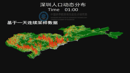
| Dynamic population distribution in Shenzhen. | Spatial distribution of stability for traffic analysis zones. | The spatial distribution of the extracted home and work locations. |
Cooperations
合作单位: |
Department of Geography, University of Tennessee, Knoxville, USA 美国田纳西大学 |
 |
State Key Laboratory of Information Engineering in Surveying, Mapping, Remote and Sensing,
Wuhan University,Wuhan 430079, China 武汉大学测绘遥感信息工程国家重点实验室 |
 |
Hong Kong Polytechnic University 香港理工大学 |
||
 |
State Key Laboratory of Resources and Environmental Information System, Institute of Geographic Sciences and Natural Resources Research, Chinese Academy of Sciences, Beijing, China 中国科学院地理科学与资源研究所资源与环境信息系统国家重点实验室 |  |
Key Laboratory of urban land resources monitoring and simulation, Ministry of Land and Resources of China, Shenzhen 518034, China国土资源部城市土地资源监测与仿真重点实验室、 Shenzhen Digital City Engineering Research Center, Shenzhen 518034, China 深圳市数字城市工程研究中心 | ||||
Copy;right © 2017 High Performance Computing Center, Shenzhen Institutes of Advanced Technology, Chinese Academy of Sciences.
Designed by Chunxia Zeng. Oct 15 2017.