

 |
 |
 |
 |
 |
 |


Space-Time GIS
时空GISParticipants in our research group
本课题组参与人员:尹凌
Keywords
关键词:ICT, Face-to-face meeting, Time geography, Space–time GIS, Activity-based model, time geography, individual activity, space–time path, social network, social media.
Description
简介:• The Space-Time GIS based on time geography is developed to explore the interactive process of individual physical and virtual activities. 研发基于时间地理学的时空GIS,探索个体的“物理-虚拟”活动交互过程。
This project is sponsored by the U.S. National Science Foundation (Grant No. 0616724) for a two-year period starting from August 1, 2006. Our research team includes researchers from The University of Tennessee, Knoxville and Oklahoma State University. The major goal of this project is to extend Hägerstrand’s time geography such that it can provide a comprehensive framework of representing and modeling both physical and virtual activities as well as the interactions between them. In addition, this research will design a space-time geographic information system (GIS) to implement the extended time-geographic framework.
Project Summary:
Human activities interact and intertwine in space and time to create a complex social system to fulfill our physiological, economic, and social needs. Recent developments in information and communications technologies (ICT), such as the Internet and cell phones, have offered people an environment to expand their activities from physical space to virtual space and are expected to lead to important changes in human activity patterns. Hägerstrand’s time geography suggests a useful conceptual framework for studying human activities in a space-time context under different types of constraints. However, the classical time geography does not offer adequate methods of representing and analyzing virtual activities and their interactions with physical activities. Furthermore, limited progress has been made in the development of an operational geographic information system (GIS) for an analytical time-geographic framework of studying physical and virtual activities. This research aims at: 1) extending Hägerstrand’s classical time geography to develop an extended framework of space-time concepts and analysis functions that can support research and applications involving both physical and virtual activities and their interactions; and 2) providing an operational space-time geographic information system to implement the extended time-geographic concepts and exploratory spatio-temporal analysis functions. Based on the extended time-geographic framework, this project will develop a space-time GIS design to support representations and analysis of the extended time-geographic concepts. One outcome of this research will be an operational prototype system to implement and assess the space-time GIS design. This project also will use a simulated activity/travel dataset and a large population migration dataset collected from a previous study to evaluate the extended time-geographic framework and its exploratory analysis functions.
The outcomes of this research, which will include an extended time-geographic framework, a space-time GIS design, and an operational prototype GIS, can provide useful foundations in support of various applications in other fields, such as activity-based transportation studies, individual-based spatially-explicit ecological modeling and epidemiological modeling, and location-based services (LBS). Such research results can help other researchers better analyze and understand the complex human activity patterns and interactions with the use of modern information and communications technologies. For example, transportation planners could benefit from this research with a space-time geographic information system design to help them analyze and gain better understanding of how individuals organize their activity and travel patterns and interact with other people in both physical and virtual spaces. Furthermore, this research has potential of contributing to the development of spatially and temporally integrated social sciences that will have broader impacts on social science research.
Project Objectives:
In this project, we will pursue two main research objectives:
1. We will develop an extended time-geographic framework that covers a comprehensive set of time-geographic entities and relationships to support research and real world applications involving studies of individual physical/virtual activities and their interrelationships; and
2. We will develop GIS approaches for representation, analysis, and visualization of the time-geographic entities and relationships identified under the extended framework and implement a prototype GIS to assess the feasibility of converting a conceptual extended time-geographic framework, through logical GIS designs, to an operational GIS in support of research and real world applications.
Project Tasks:
Four tasks are identified and will be carried out in this project:
Task 1: Develop a comprehensive extended time-geographic framework that addresses various time-geographic concepts applicable to physical activities and virtual activities as well as the interrelationships between physical and virtual activities;
Task 2: Design GIS approaches for representation of various time-geographic concepts developed under the extended time-geographic framework;
Task 3: Development of spatio-temporal analysis functions in the GIS environment; and
Task 4: Evaluation of the proposed extended time-geographic framework and GIS design.
Publication
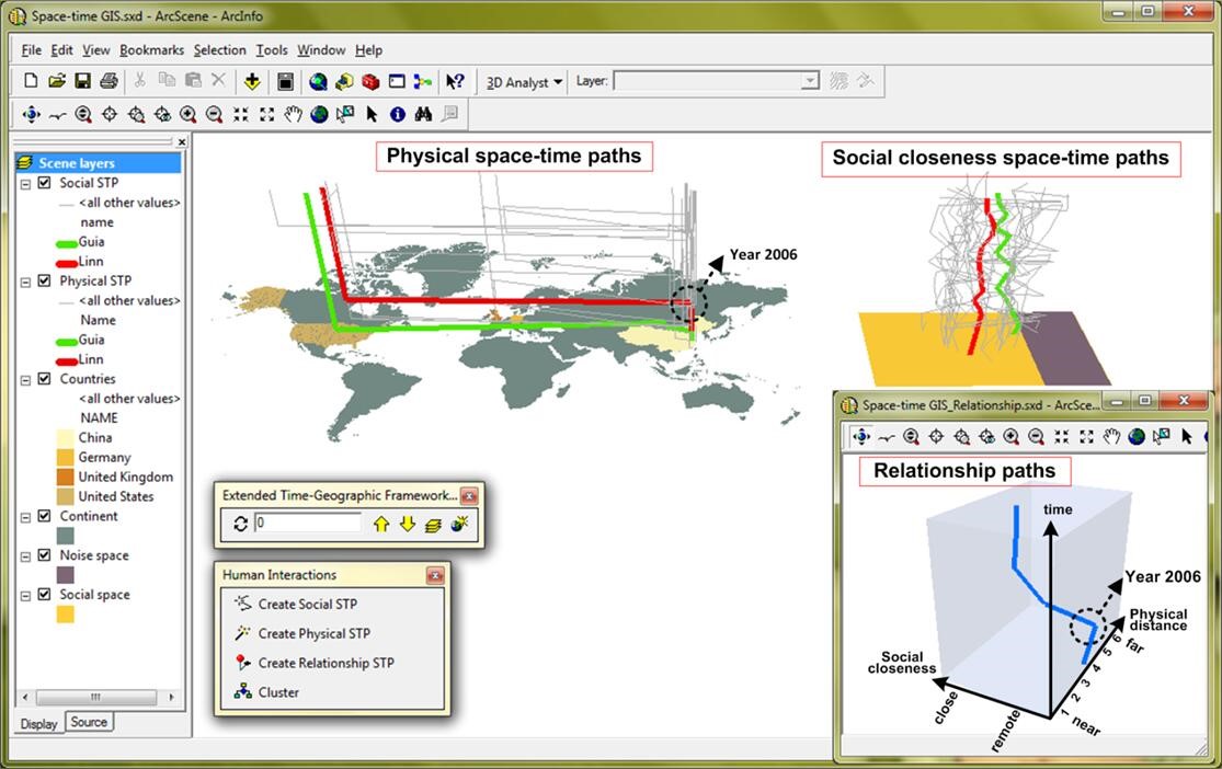
论文:Ling Yin, Shih-Lung Shaw, 2015. Exploring space-time paths in physical and social closeness spaces: a space-time GIS approach. International Journal of Geographical Information Science, 29(5): 742-761. (SCI)
Ling Yin, Shih-Lung Shaw, and Hongbo Yu, 2011. Potential effects of ICT on face-to-face meeting opportunities: A GIS-based time-geographic exploratory approach. Journal of Transport Geography, 19(3), 422–433. (SSCI)
Ling Yin, Shih-Lung Shaw, 2011. A space-time GIS for dynamics in potential face-to-face meeting opportunities. In Proceedings of the 2011 international workshop on Trajectory data mining and analysis (TDMA '11). ACM, New York, NY, USA, 15–22. (EI)
 |
 |
|
| ICT影响下的个体间交互机会动态分析 | 挖掘物理移动-社交网络活动交互关系 |
Cooperations
合作单位: |
Department of Geography, University of Tennessee, Knoxville 美国田纳西大学 |
 |
Department of Geography, Oklahoma State University, Stillwater, Oklahoma 74078-4073, United States 美国俄克拉荷马州立大学 |
||||
Copy;right © 2017 High Performance Computing Center, Shenzhen Institutes of Advanced Technology, Chinese Academy of Sciences.
Designed by Chunxia Zeng. Oct 15 2017.